Article Taken from MoonshineInk.com
It seemed like the snow would never stop falling this winter, and Tahoe/Truckee is just now, at the end of April, beginning to see the massive snowpack begin to melt, at least at lower elevations. Up high, that’s another story, and in January, February and March, if it wasn’t snowing, it was raining. So all this rain and snow in early 2017 begs the question — was this a record setting year?
The answer is both yes and no, depending on whether you are looking at precipitation or snowpack.
In terms of precipitation, 2016/17 is shaping up to be the wettest year on record since the Federal Water Master’s Office in Reno started keeping track 118 years ago. According to U.S. District Court Water Master Chad Blanchard, while we are behind 1982/83 with regards to total precipitation, there are still five months to go in the water year (Oct. 1 to Sept. 30), and we are currently ahead of where we were in April of 1983.
“We are way ahead, above any year to date as far as run-off — run-off in the Truckee River and the rise of Lake Tahoe,” Blanchard said. “We will possibly exceed the biggest run-off year (1983) by 30 percent. Thirty percent is huge. It’s been an absolutely tremendous year.”
As of April 20, Lake Tahoe was sitting at 6227.69 feet, 4.5 feet above its natural rim. (The lake’s maximum legal limit and flood stage is 6229.1.) This puts 2016/17 as the second biggest year so far for the water level rise in Tahoe in April, “and we haven’t really melted any snow up high, in fact there has been an overall gain in snow,” Blanchard said. In contrast, 2015, which was the driest year on record for snowpack, saw the lake stop rising in April. As of now, this year is on track to beat the all-time record of inflow to Lake Tahoe in 1907 by 20 percent.
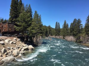
As of April 22, all 17 gates of the Lake Tahoe Dam were open. A few days earlier on April 20, the Truckee River at Farad was running at 5,160 cubic feet per second (cfs), setting a new record for that date. By comparison, the average at this time of year is 900 cfs. The April 20 record holder was 4,100 cfs in 1938, 25 percent less than this year. For a short period in 1997, a winter remembered for its floods, the river was running at 14,900 cfs at the Farad site.
Blanchard said he is not worried about flooding downstream in Reno, yet.
“If we get rain, it changes everything. Hopefully we will have a nice, steady melt,” he said. “It’s likely to be the highest flows in Reno we have ever seen just from snowmelt.”
Blanchard said that the Truckee River’s flow should slow down around mid-summer, when evaporation normally becomes greater than in-flow.
While the winter of 1982/83 currently holds the record for most precipitation, 1993 holds the record for biggest snowpack in the region. This winter is unique because the region has both: almost record-setting precipitation and a large snowpack. However, while hard to believe for residents who lived through Januburied, when almost 20 feet of snow fell on the area in January (by the end of April Sugar Bowl reported almost 66 feet of total snowfall), the snowpack did not break any records this winter.
According to the California Department of Water Resources’ David Rizzardo, chief of snow surveys/water supply forecasting, as of April 1 the Lake Tahoe Basin snowpack is 176 percent of average, and the Truckee River Basin snowpack is 193 percent of average, thanks to as many as 10 atmospheric rivers that hit Northern California this winter. On average, Northern California gets five to seven atmospheric rivers per wet season.
“While all well above average, this is not a record-setting year by any measures,” Rizzardo said. “We are quite a bit lower than April 1983.”
In April 1983, the Lake Tahoe Basin snowpack was at 208 percent of average, and statewide at 227 percent. By contrast, 2015’s snowpack was at 5 percent of average statewide. This year, California as a whole is at 163 percent of average.
This puts 2016/17 at number seven for biggest snowpack, with 1952 holding the number one place for largest snowpack statewide. The Department of Water Resources has been keeping records since 1921.
With 30 percent of California’s water supply coming from the state’s snowpack, the Golden State is in great shape with regards to water, and on April 7 Gov. Jerry Brown officially announced that the state’s drought is over. The good news: there are still five months of the water year left, and lots of snow still to melt. Rizzardo predicts that the region could see another 8 inches of precipitation by October, adding to the 92.4 inches the Northern Sierra has accumulated as of April. But Rizzardo offers a word of caution — although the state’s reservoirs are close to full, they only hold two to three years of water supply.
If the past is any indicator of California’s future, the only thing for certain is that another abundant water year like 2016/17 is anything but a sure thing.
